Menu of this site

The plateau of Paúl da Serra

Published page
Headings[Photos] [Presentation] [Situation] [Visits] [Culture] [Practical Information] [Other topics]

[Madeira] [Parent topics] [Next topics] [Via Gallica]

PresentationPresentation

General presentationGeneral information
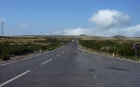
. Click to enlarge the image.. Click to enlarge the image.The sorry plate of Paúl da Serra is immense a wide perfectly horizontal punt and lunar (from 1,410 to 1,440 m); it is spread out over about thirty km². The landscape, here, points out that of the dull Scottish plains often disappearing in the fog or the clouds: one hears there only the noise of the wind and, possibly, the bleats of the black sheep…

This “marsh” is flooded in winter: water infiltrates in this season, whereas it evaporates in summer.

It is also the crossroads of tracks, roads and ways which make it possible to make excursions in the center of the Madeira.

EtymologyEtymology
Paúl da Serra: the fen of the mountain, the marsh of the mountain.

SituationSituation

The plate of Paúl da Serra dominates in north the commune of Calheta; its water feeds the hydroelectric station of this city starting from a tank.
. Click to enlarge the image.. Click to enlarge the image.
. Click to enlarge the image.. Click to enlarge the image in Adobe Stock (new tab).
. Click to enlarge the image.. Click to enlarge the image.
. Click to enlarge the image.. Click to enlarge the image in Adobe Stock (new tab).

VisitsVisits

Northern slope
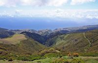
The northern coast seen since the plate of Paúl da Serra with Bica da Cana. Cliquer pour agrandir l'image dans dans Adobe Stock (nouvel onglet).
Eastern Slope
The slope east dominates the collar of Encumeada.
. Click to enlarge the image in Adobe Stock (new tab).. Click to enlarge the image in Adobe Stock (new tab).
. Click to enlarge the image.. Click to enlarge the image.
Southern slope
The road between Paúl da Serra and Boca da Encumeada dominates the southern slope of the island, offering very beautiful sights on the tops which overhang the planted coast of banana trees.
. Click to enlarge the image.. Click to enlarge the image.
. Click to enlarge the image in Adobe Stock (new tab).. Click to enlarge the image in Adobe Stock (new tab).
. Click to enlarge the image.. Click to enlarge the image.
Lombo do Mouro
. Click to enlarge the image.. Click to enlarge the image.
. Click to enlarge the image.. Click to enlarge the image in Adobe Stock (new tab).
. Click to enlarge the image in Adobe Stock (new tab).. Click to enlarge the image.
. Click to enlarge the image.. Click to enlarge the image in Adobe Stock (new tab).
. Click to enlarge the image in Adobe Stock (new tab).
Western slope
The western slope of the plate opens in the area of Rabaçal on the valley of Ribeira da Janela.
. Click to enlarge the image in Adobe Stock (new tab).
Excursions
Preserved perfectly, Paúl da Serra is a small paradise for the avid hikers of great lonelinesses, especially because of its arid and stripped nature so different moreover from the island; many paths furrow the girdled plate of a lace of tops (refuges with Rabaçal, Estanquinhos, Bica da Cana and Lombo do Mouro).

Because of the very frequent fogs which go down abruptly, the walkers may find it beneficial to be made accompany by a tested guide. One of the paths borrows the tunnel (furado das Levadinhas), 600 m length (essential flashlight) which passes under the central peak of the island, directed of is in west and forming the watershed.

The vegetation is composed of ferns and foam beds; curved, shrivelled, the arborescent heather is due despite everything head to the wind which blows permanently: cloud and layers of fog often plane above ground.

History and traditionsHistory, literature, arts, traditions, legends, religions, myths, symbols…

EconomyEconomy
Paúl is used as pasture: happy sheep and oxen evolve there with their ease whereas everywhere else, the animals lay out only narrow paiheiros.
A park of wind mills produced of electrical energy, benefitting from the quasi permanent winds of the plate.
. Click to enlarge the image in Adobe Stock (new tab).. Click to enlarge the image in Adobe Stock (new tab).

InformationPractical informations

HotelsHotels
Pico da Urze

Other topicsOther topics

Filiation of the topics
More detailed topics
Close topics
The plateau of Paúl da Serra
The pico do Arieiro
The pico Ruivo
Broader topics
Madeira
The island of Madeira
The septentrional coast of Madeira
The Eastern coast of Madeira
The southernmost coast of Madeira
The Western coast of Madeira
Interior of Madeira
The island of Porto Santo
The islands Desertas and Selvagens
[Parent topics] [Next topics] [Home page] [Madeira] [Via Gallica]
Search on this Site
Search on the Web
Recommend this page
Recommend this site
Translate this page
AlbanieAllemagneAngleterreArméniePays basqueBiélorussieBulgarieCatalogneCroatieDanemarkEspagneEstonieFinlandeFranceGalicePays de GallesGéorgieGrèceHongrieIrlandeIslandeItalieEmpire romainLettonieLithuanieMacédoineMalteNorvègePays-BasPolognePortugalRoumanieRussieSerbieSlovaquieSlovénieSuèdeTchéquieUkraïne
If you reached this frame directly, click on this link to reveal the menus.